
When you get off at the Wiener Platz stop in the district of Mülheim, you’re surrounded by busy traffic and bustling pedestrians. Steeped in a history of industry, immigration and intercultural communities, Mülheim has more inhabitants than any other neighbourhood in Cologne and it’s also one of the city’s most vibrant districts. Heading along Buchheimer Straße, you soon come to a good place for your first stop – Café Vreiheit on Wallstraße to the right. They have a wide selection of breakfast choices, lunch options and mouth-watering cakes. When the weather’s nice, the idyllic café terrace right next to the Friedenskirche church is a lovely spot to linger.
Before we start the actual tour, it’s worth taking a short detour to the Rhine to see two of Mülheim’s famous landmarks: here, in front of St. Clemens Church, which dates back to the middle ages, stands Saint John of Nepomuk, patron saint of bridges, admiring the gorgeous view across the river and over to the Mülheimer Brücke bridge.
Schanzenviertel – Mülheim’s new commercial district
But now it’s time to get pedalling! We cycle down Wallstraße, onto Dünnwalder Straße, which then becomes Berliner Straße, before turning right twice and left once to arrive at Mülheim’s new Schanzenviertel quarter. Buzzing with industry (including the Felten & Guilleaume cable factory) in the 19th and early 20th centuries, today this area is home to businesses, cultural institutions and event venues.
Fans of live music are often to be seen here, for instance, flocking to the E-Werk venue and the Palladium opposite, which was originally built as a machine shed at the end of the 19th century. The site’s red bricks lead you to Carlswerkstraße. Here you turn right and not long after right again through a large gate into the Carlswerk site. In a previous life, the buildings here were factories but now you’ll find the likes of Tesla, the Stuntwerk bouldering centre, Bastei Lübbe Verlag publishing house and Depot, the interim performance venue of Cologne’s Schauspiel Köln theatre. Right in front of it blossoms the CARLsGARTEN urban gardening project, full of greenery and veggies.
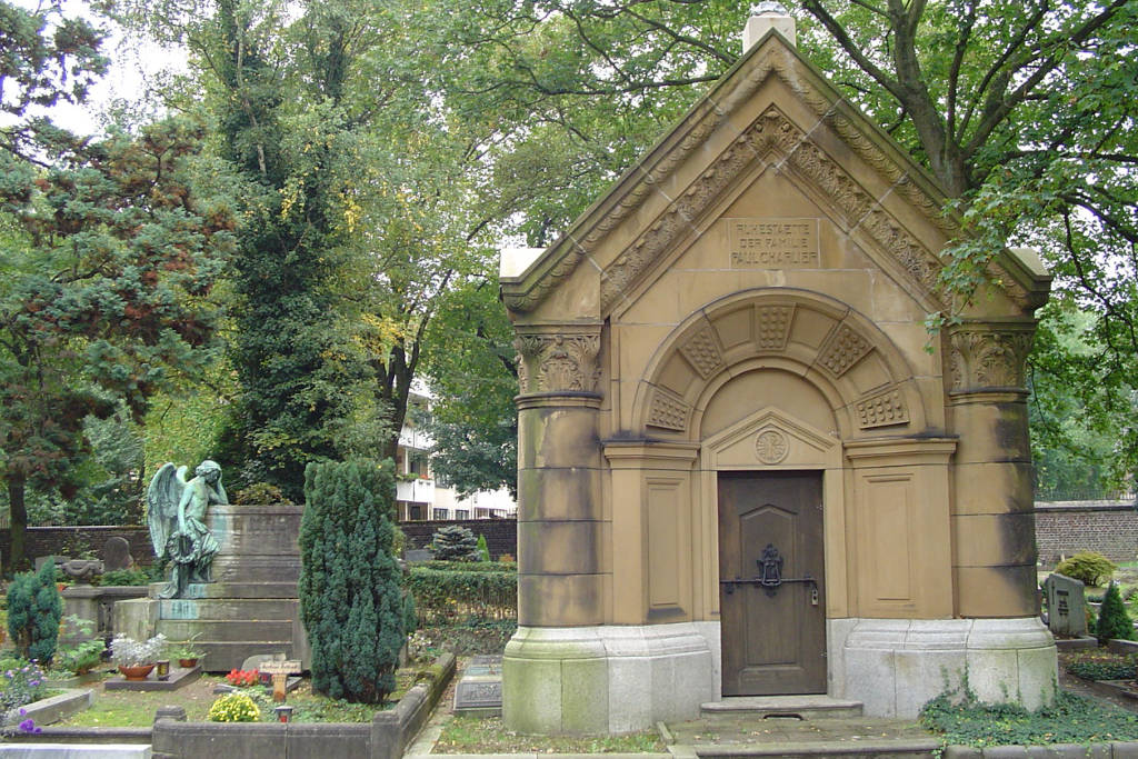
An island of calm amidst the urban hustle and bustle: Mülheim’s protestant cemetery
Just a stone’s throw away to the left of the Carlswerk site lies Keupstraße – the beating heart of Cologne’s Turkish community since the first migrant workers were recruited in the 1960s. Today, it’s mainly made up of Turkish restaurants, such as the popular Mevlana, kebab shops, bakeries and jewellery stores.
After all the frenzy of Keupstraße, an island of calm awaits. Mülheim’s protestant cemetery on Bergisch-Gladbacher-Straße dates back to 1612 and has the graves to prove it. The cemetery has protected status and is still used for burials today. It has a very special atmosphere, which you can get a sense of if you take a short walk around. Moving on just a few minutes by bike, the Mülheimer Stadtgarten park is equally as relaxing albeit it exactly 300 years younger. It has green meadows, a pond bordered by stately weeping willows and a fairytale fountain by Cologne sculptor Wilhelm Albermann.
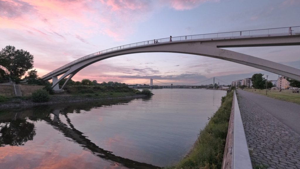
Now the Rhine beckons again. Travelling along Bergischer Ring, you cycle towards Wiener Platz, turning left onto Bachstraße just before you reach it. After the steep climb to the peak of the pedestrian and cycle bridge, slide down onto “Mülheim Island” and then, with the harbour and old factories facing you, beneath the Zoobrücke bridge and straight into the Rheinpark.
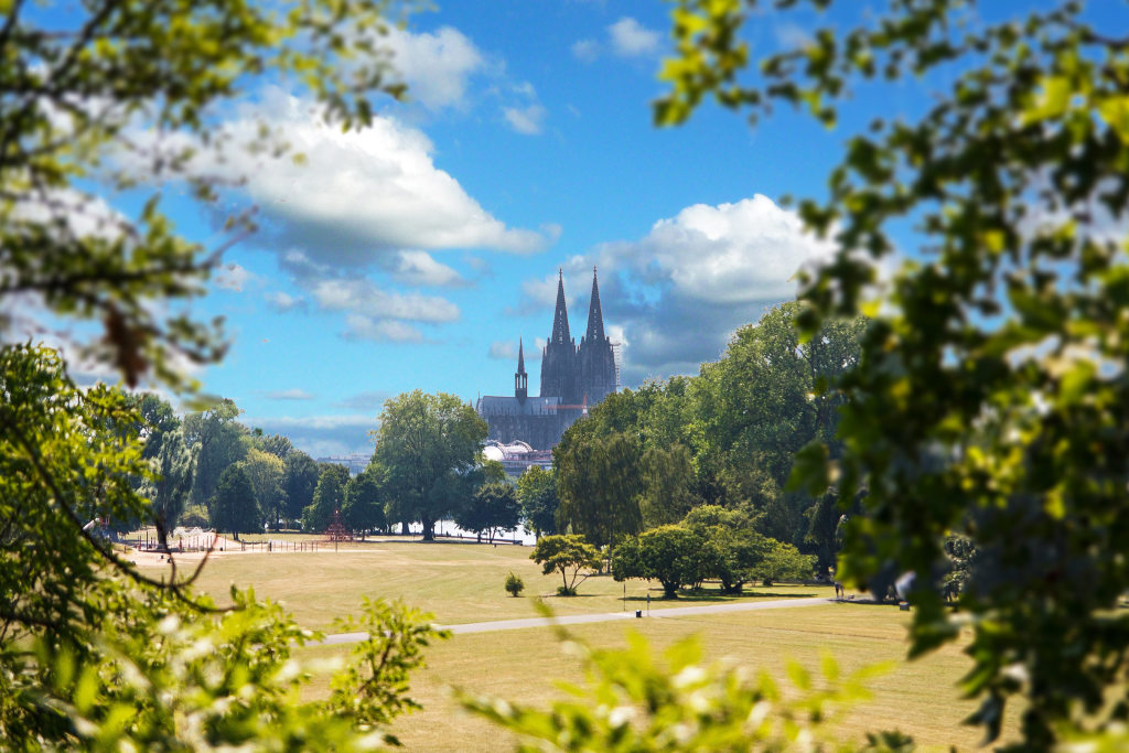
An unrivalled view of Cologne Cathedral and the Altstadt district
With its superb view of the cathedral, this is a very popular park for a walk. Its current form dates back to the 1957 Bundesgartenschau (national garden show). Families come here for picnics, children play in the fountains, joggers go for a run and there’s even a mini train. The right-bank station for Cologne’s cable car is here too. In 2022, the Park-Café, a protected building, finally re-opened after a four-decade wait and an extensive refurbishment.
There’s an unrivalled view of the cathedral and the old part of the city, the Altstadt, from here and from behind the Hohenzollernbrücke bridge and the stairs leading up onto it – the perfect place for a photo! But our route takes us away from the Rhine now, past the domed structure of Köln Messe/Deutz railway station and uphill slightly towards one of the city’s largest venues, the Lanxess Arena.
Taking Gummersbacher Straße, you move on to the neighbourhood of Kalk. The Pyramidenpark and the home of the Kölner Haie ice hockey team whizz by on the right; fire engines and ambulances shine brightly behind the large glass doors of the local emergency services station. And then you get to Bürgerpark Kalk. This district has a rich industrial history too, as reflected by the old water tower of the Chemische Fabrik Kalk. Built in 1904 and standing more than 40 metres tall, the tower is all that’s left of the factory today.
Kalk: tipped to be the next hip district
Vorsterstraße, not exactly wide itself, leads to Kalk-Mülheimer Straße, which is hardly much wider. The neighbourhood’s industrial decline brought a decline in prosperity too. The decades that followed were not easy, as is clear to see in many parts of the district. Despite that – or perhaps because of it – people are tipping Kalk to become the next hip district. Judging by cute café Villa Kalka, the marvellous Lichtspiele Kalk arthouse cinema on Kalk-Mülheimer Straße and vegan Nudelbar Nobiko the next street over, they could well be right. As we move on though, from Wipperfürther Straße to Remscheider Straße to Bertramstraße, the surroundings take on an almost village-like flair. Then it’s down Engelsstraße, Feldstraße, Marktstraße and Steprathstraße to the main thoroughfare: Kalker Hauptstraße.
A traditional Cologne treat awaits you here – a glass of kölsch from Brauwelt Köln, established in 2021 as the new name for the city’s two oldest kölsch breweries and distilleries (Sünner Kölsch and Mühlen Kölsch). The yellow brick façade of the building (dating back to 1890) is a delight to behold, as is the view of the shiny copper kettle through the large window. Brewery and distillery tours are available and there’s a beer garden for an al fresco kölsch or you can soak up the atmosphere in the brewery’s pub. The food menu features traditional Cologne dishes (how about some Himmel un Ääd or Halven Hahn?) plus international cuisine with a local twist.
Charmingly different gastro spots in Kalk
Once you’re feeling suitably fortified, there’s more of Kalk to explore. Wiersbergstraße has two charming alternative places to grab something to eat or drink: vegan Trash Chic and Bambule Kaffeebar. And then there’s Abenteuerhallen Kalk, where the activities include climbing, circus classes or practising tricks in the skatepark.
Past industrial wasteland and beneath railway arches, our tour takes us on to the mighty edifice that is St. Engelbert’s church. Then come hairdressing salons, kiosks, oriental supermarkets, German kölsch bars, a Moroccan mosque and a tattoo studio, indicating Kalk’s status as another of the city’s multicultural melting pots. Travelling back via Taunusstraße, you get to Gießener Straße with its gigantic mural by the “innerfields” art collective, which was inspired by Caspar Davids Friedrich’s famous “Wanderer above the sea of fog”. Behind the figure holding a smartphone, Cologne’s Altstadt district is visible in the background.
Poller Wiesen park – the grand finale of our cycle tour
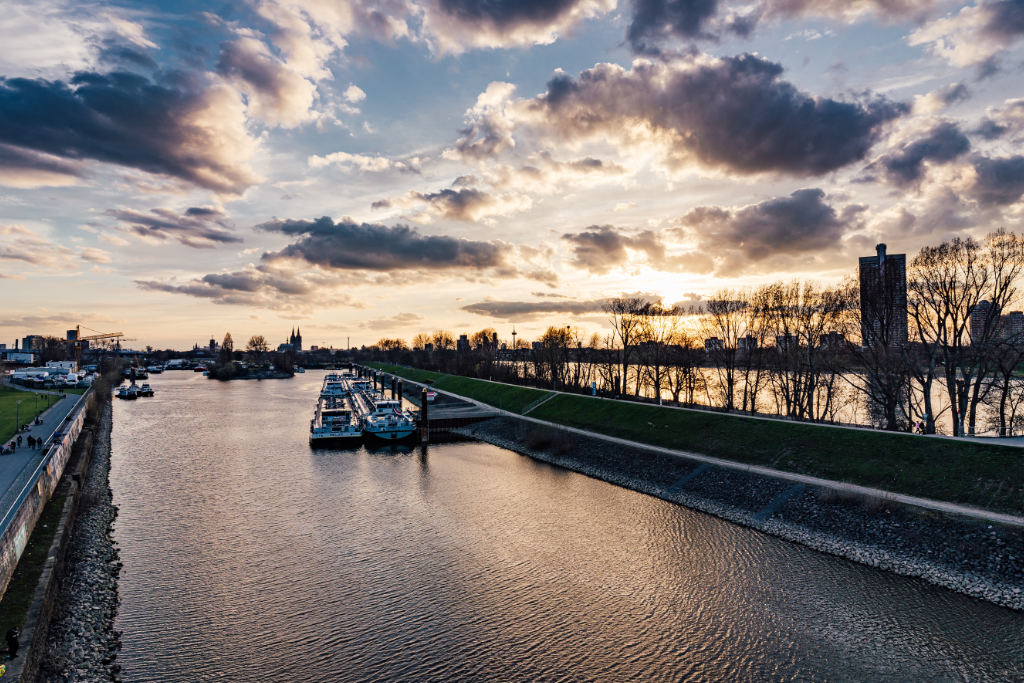
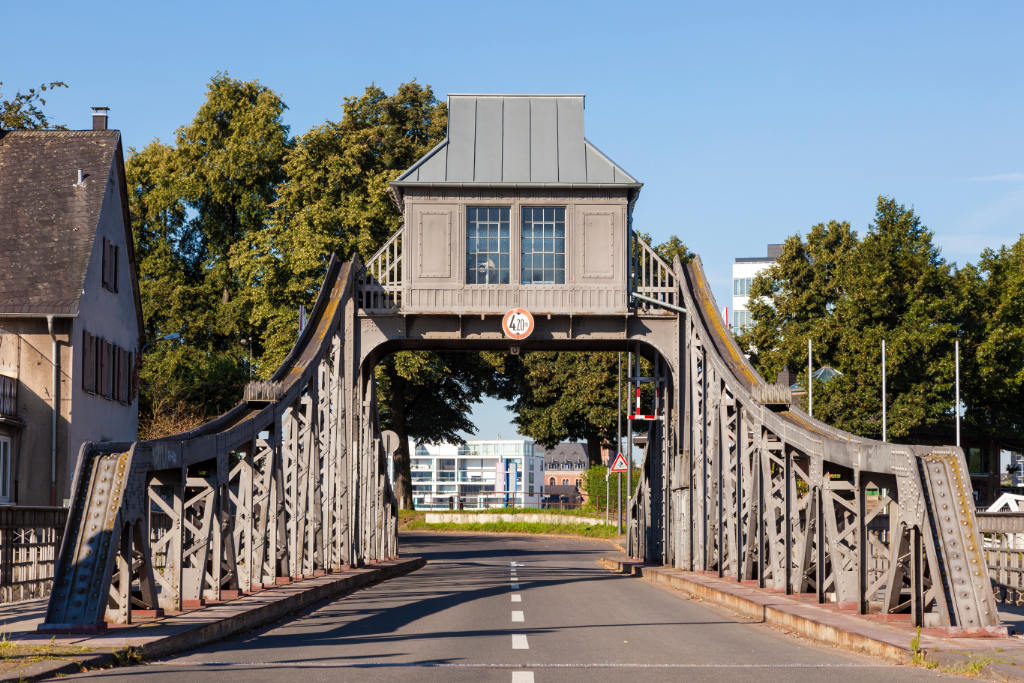
But now, finally, it’s down to the Rhine! Gießener Straße brings us to Deutz-Kalker-Straße, from where you can cycle along Deutzer Freiheit towards the riverbank. Travelling downstream along the Deutz dockyard, where the neighbourhood kids like to shoot hoops on the basketball courts, you pedal along beneath the gleaming green Severinsbrücke bridge towards Deutz harbour.
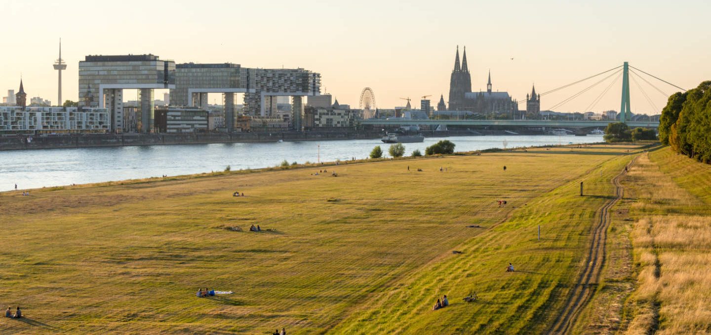
Beyond the recently renovated Deutz swing bridge lies a peninsula with expansive riverside meadows and the finale of our tour: the Poller Wiesen park. As well as being a great place for a bike ride, you can enjoy a stroll here, watch people flying kites or just lounge in the grass. All accompanied by a terrific view of Cologne’s skyline with the cathedral, Altstadt, the Rheinauhafen harbour district and the “crane houses” – the ultimate panoramic view of the city.
0 comments on “A cycling tour on the right bank of the Rhine: the cool side of town”